This was a long, somewhat challenging day; not bad overall, just not like the one driving up the coast. If you're keeping count, this is the 5th full day in Cali, and that total would not be surpassed by any other state, even New York, which I visited twice.
This is where my day started, Josh's apartment:

I wish I'd slept more hours on that couch, I'd been up late working on that laptop, and I had to be out of the apartment by 8am as the three roommates all had to go to work on this Tuesday. I maybe ate a granola bar before packing up my stuff and heading out the door, to where my car was parked on Potrero:


I was badly in need of coffee, so I started walking south on Potrero in search of Philz Coffee, a recommendation from my hosts that's a local San Fran shop. I thought my destination was around Potrero and 24th Street, and I also needed some sunscreen from CVS along the way. It turned out to be a longer walk that I'd thought, so it sapped my energy, resulted in no Philz, and the humid warmth kinda got me sweating even at this earlier hour.
The walk was a good way to get a feel for the basics of San Fran though. It's as walkable as LA and San Diego are drivable; San Fran has about 17,000 people per square mile, as compared to 8,000 per sq. mi. in LA city proper and maybe 4,000 in San Diego. The bus, the streetcar and the bike, as well as pedestrians, rule the road in this city. Here's 2 views toward Twin Peaks, and 1 looking to the east toward the highway nearby:


There were many people walking the sidewalks, and one homeless person that smelled of cigarette smoke who got $3 out of me. It was noisy too, because of all the buses and streetcars and all the city noise that I could hear from the surrounding blocks. I did get the sunscreen from CVS on the way back, but I didn't appreciate the pre-9am sweating. Here's a montage of the 2-3 story rowhouses that San Franciscans live in:


I guess I didn't want to take the bus back to the car because I felt like I had lots of time to spare by getting up unusually early. I was happy to get back in the car, fire up the Top Gun Anthem, and drive at a max of 25mph to Philz, which happened to be near the corner of 24th and Folsom:

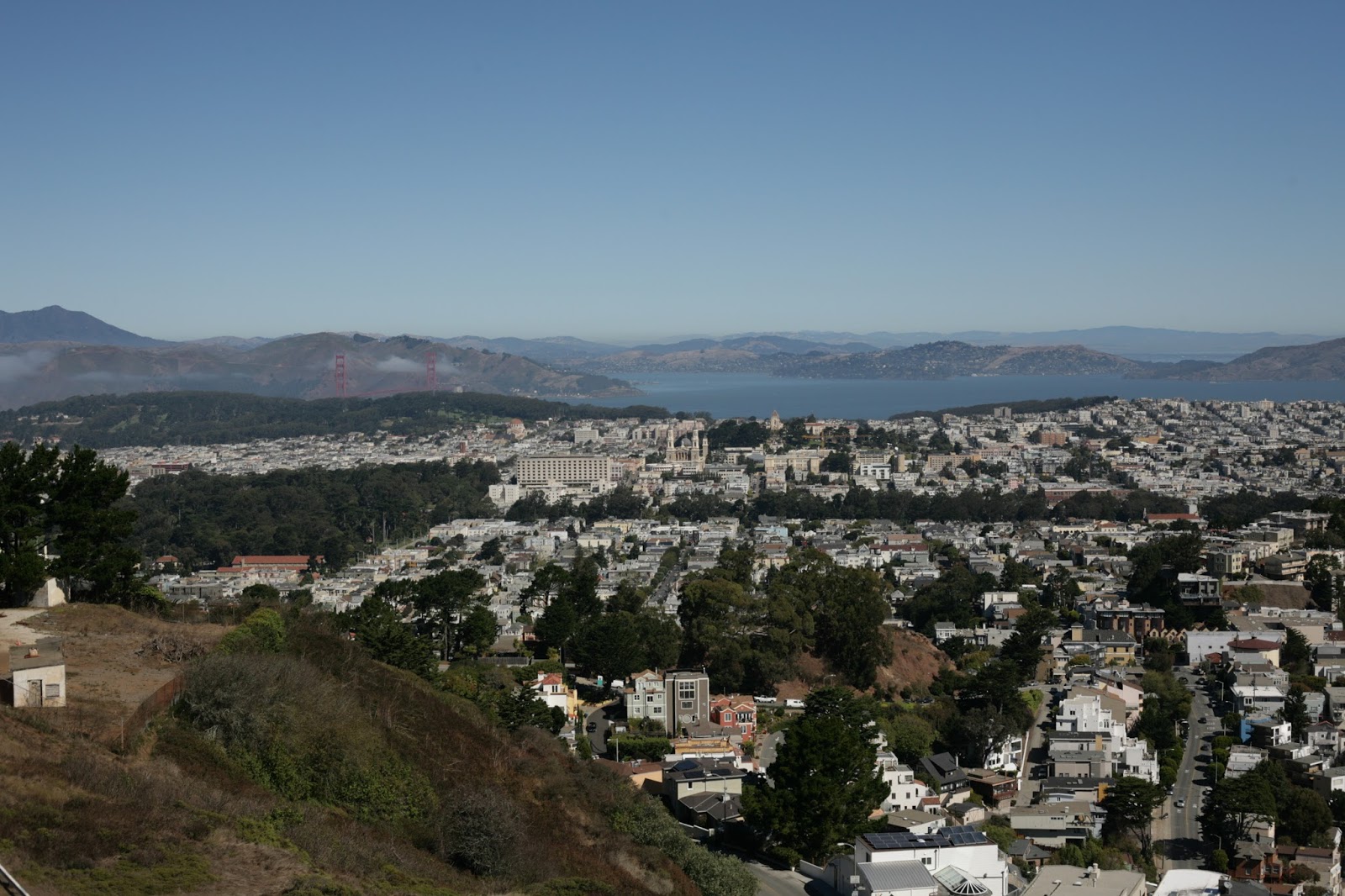
My hosts had highly recommended that I check out Twin Peaks, the highest point in San Francisco, which is two hills that are 900 feet above the sea level close by. On a foggy day, one can only see fog and a few of the tallest towers poking out of it, but this was a perfectly clear day. I wound my way from Potrero over to the climbing, winding roads to the peaks, and voila, I could see directly down Market Street to downtown:


Come to think of it, being at the top of the peaks on a sunny day probably didn't help my sunburn, but it was totally worth the drive up there! Oh, you want more from Twin Peaks? Here you go then:


Now, having seen in great variety how crazy hilly and dense San Francisco is, I would be remiss in leaving out the famous car chase scene from Bullitt, the first good car chase scene in history (Steve McQueen and the bad guys take off around 2 minutes in):
After taking all these incredibly clear pictures from Twin Peaks, I checked the map, to find out how to get down from there and on to Golden Gate Park. I took some of those switchbacks from the top and wound my way down toward the “lowlands” of San Fran. I went down a street that was so steep, I put the gear in 1st and actually crawled the car down the hill, only touching the brakes at the very bottom for the stop sign there. That's another one of those "can't do that in Dallas" things.
Golden Gate Park was…very lush and green. I cruised around a few of the
roads within before finding a parking spot and getting out to take some
pictures of the garden areas and other flowery areas that my mom and
grandmother would appreciate:


From Golden Gate, it was time to cross the city, driving
through downtown to Pier 39 along the Embarcadero, which is the road running
along the piers in the bay. It used to be a segment of Interstate 480, but
after its second level collapsed during the 1989 World Series earthquake, the
city decided to tear down the highway and rebuild the harbor area. I think it
was a good idea, based on my experience there.
First I had to get there, which was, uh, tricky. This was
when I could’ve used the services of a navigator. I got confused at one
intersection, and ended up taking a few impromptu turns to correct my course
and wound up waiting under this bridge for a much needed lane shift and left
turn on Market Street up ahead:

And aha! I made it onto Market Street, which makes a
diagonal beeline from near Twin Peaks to the Embarcadero right down the middle
of downtown. I took this street slowly, block by block, with many of San
Francisco’s tallest buildings on either side and tons of shops and pedestrians
going by at ground level:


Notice there were tons of cables for streetcars, and the
buses are longer than the ones in Dallas, they have to bend in the middle to
make the tight corners there. I drove past many waterfront buildings until I
found parking reasonably close to Pier 39 for the not so reasonable price of
$32…doh!


After parking, I found the aquarium nearby for some pictures of the sea creatures, and displays of how cold the Pacific is in this area (very) and where the Great White sharks may be hanging out:


And now it was time to venture all the way down the pier, past many, many shops and throngs of people and even a performer of sorts:


Now, the Sea Lion Café: Best fish'n'chips I've ever tasted. Bar none. Not replicated even since then. It was $20, and I savored every bite. The Duckies had a great time sitting in the window looking out at the piles of sea lions, as seen in an Instagram that day. On the way back, I saw a carousel, Treasure Ireland, and other fun shops:


I got the car out of that ungodly expensive garage, and this is the part where I forgot to drive on Lombard St. Let me explain...
Lombard Street is the world's curviest road, and has a speed limit of 5 mph for good reason. It's San Francisco's famous road that crawls one way down Russian Hill, with a direct line of sight to the bay east of San Fran. It's featured in multiple movies, and the one I remember it from is of course George of the Jungle!

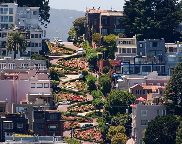

Incidentally, I passed right by this area on the way from the pier to the Golden Gate Bridge. I mean, it would've been the easiest thing in the world to detour maybe 2 or 3 blocks north from Union Street to drive Lombard, but no, I'd forgotten to even ask Josh about it or look it up at all. Next time, it's on the San Fran bucket list. Just to say I've driven on it. Ok, now, time to experience some American engineering:


Yep, pretty cool to drive on America's most famous bridge. The speed limit's even reasonable as you can see. No fog today, so no R.D. McClenagan-esque Instagram masterpieces, but seeing how very, very tall the bridge towers are was rewarding enough. If you ever drive over it going north, know that the first exit and a left turn takes you up a winding road to Hawk Hill, where, like the main characters in Assassin's Creed, you can perch up high and view the whole shebang:


Back to Hawk Hill:
Container ship that looks like a toy boat from this far away:

You can also see almost every square inch of San Fran:


So would Tony Bennett:
Leaving Hawk Hill, I drove back down to the 101, and made the grave error of driving north on it in rush hour, toward San Rafael. I hit traffic quickly, and fought that for maybe 30 minutes, until I got to Novato, where I turned east onto Highway 37. This was an even worse decision than the whole 'take 101 and ignore I-580 to cross a bridge over the bay and take a more direct route to Sacramento. No no, Hwy 37 goes around the north end of the bay, and it was choked with cars this late afternoon. It took more than an hour to cross this relatively short stretch of road to reach Interstate 80. I was low on snacks and had no water with me, so by the time I got past all that mess and was getting into Sacramento, I was freaking physically drained. I'd also about lost my mind just sitting on this highway with no towns anywhere nearby. I eventually passed by Sacramento, as I didn't have any interest in going into the city itself. It's in the middle of the state, in a part of the San Joaquin Valley, which is mostly flat and dry, not many trees:


I stopped in Folsom, CA (because of the Johnny Cash song)...
...and because it had an In-N-Out Burger, and I desperately needed food and water. I was dehydrated enough that I felt sick to my stomach and light-headed, which was poor planning on my part. I ordered my food and literally chugged water waiting for the meal to come out. But it all turned out fine, I refueled with a delicious double-double and fries, and headed east on US 50 into the forests near Lake Tahoe. No pictures from this area, it was already nighttime when I was passing through. Just more music!
This portion of the drive kind of resembled my drive east of Big Bear Lake in the LA area a few days earlier. The speed limit was around 55, it was very dark, and it was all sweeping corners and pine trees flashing by on either side of the road. In other words, peaceful. I drove more than an hour from Folsom to South Lake Tahoe, and listened to the Man In Black's song "A Boy Named Sue" a few times haha. Always good for a smile or a chuckle, for I tell ya, life ain't easy for a boy named Sue:
If you like what you've read, subscribe in the upper right sidebar to get updates via Email, thanks!
Note: This post contains Amazon Affiliate links on which I make a
commission if you opt to buy the product through that link. Thanks for your
business if you choose to go that route!
No comments:
Post a Comment